Scientific Communications
Peer-reviewed articles, scientific reports, and conference proceedings
Filter by keyword or browse through all below
Keyword
- Aboveground Biomass
- Agricultural Employment
- Agricultural Expansion
- Agricultural Intensification
- Agricultural Yields
- Agricultural monitoring
- Augmented Visual Interpretation
- Belowground Biomass
- Carbon Stocks
- Climate Change Mitigation
- Collect Earth
- Cropland
- Cropland Dynamics
- Deforestation
- Development
- Drivers of Deforestation
- Dryland Forests
- Drylands
- ECOWAS
- Ecosystems
- Fallow cropland
- Field Size
- Forest Degradation
- Forest Restoration
- Forestry Plantations
- Global Assessment
- Google Earth
- Google Earth Engine
- Interdisciplinary
- Land Monitoring
- Land Systems
- Land Tenure
- Land Use
- Land Use Change
- Land Use Management
- Land use policy
- Large-scale Land Acquisition
- Large-scale Land Acquisitions
- Mali
- Mangroves
- Mapathon
- Mozambique
- National Forest Monitoring System
- Open Source
- Participatory GIS
- Pixel-based Compositing
- Remote Sensing
- Resource Frontiers
- Restoration Longevity
- Restoration Policy
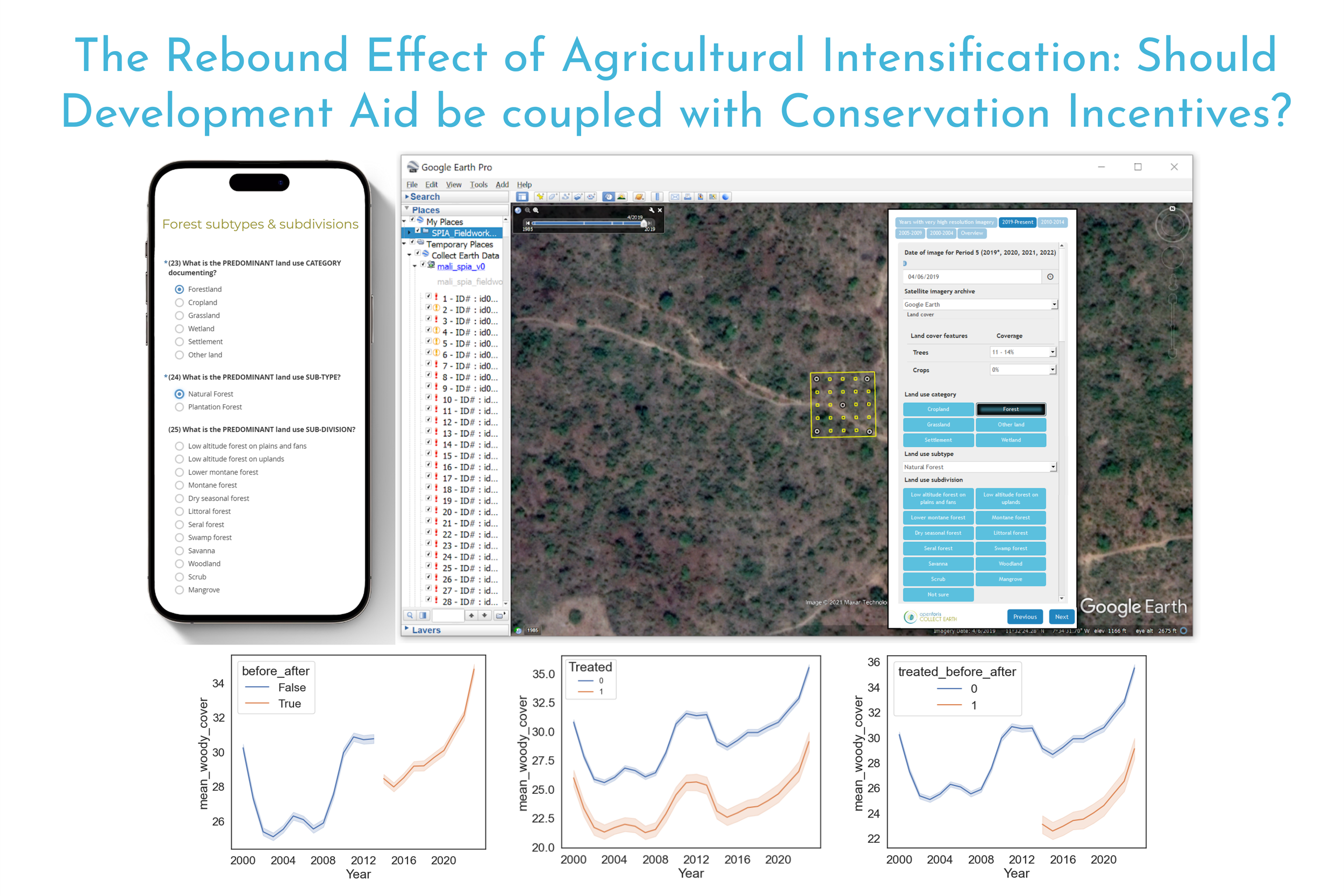
The Rebound Effect of Agricultural Intensification: Should Development Aid be coupled with Conservation Incentives?
The rebound effect of agricultural intensification
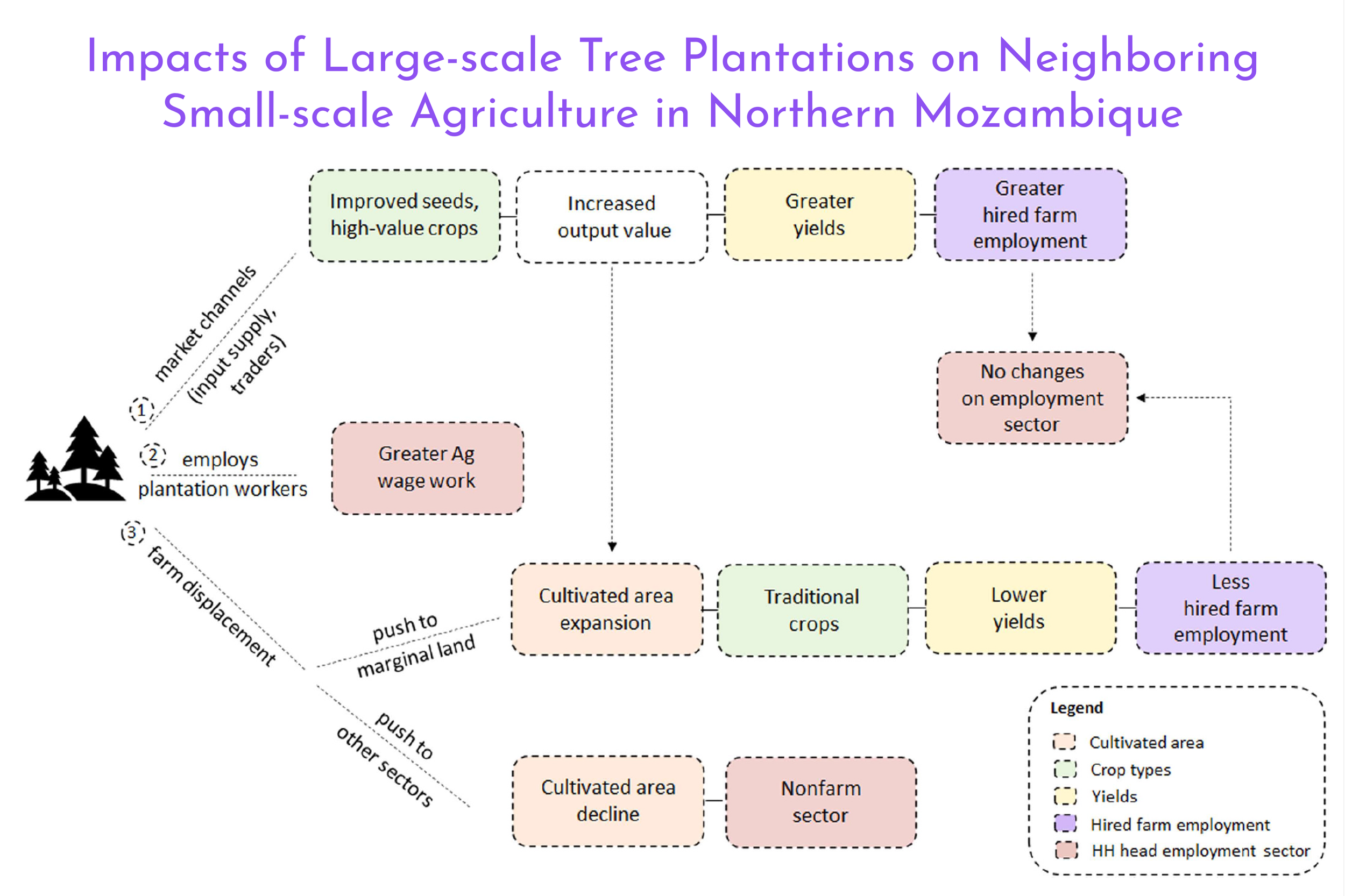
Impacts of large-scale forestry investments on neighboring small-scale agriculture in northern Mozambique
(1) Study integrates remote sensing and household surveys to assess forestry plantations impact. (2) Forestry investments lead to farmland expansion but decreased yields. (3) Lack of evidence for direct employment from forestry investments. (4) Rethinking reforestation plans is key for inclusive development.
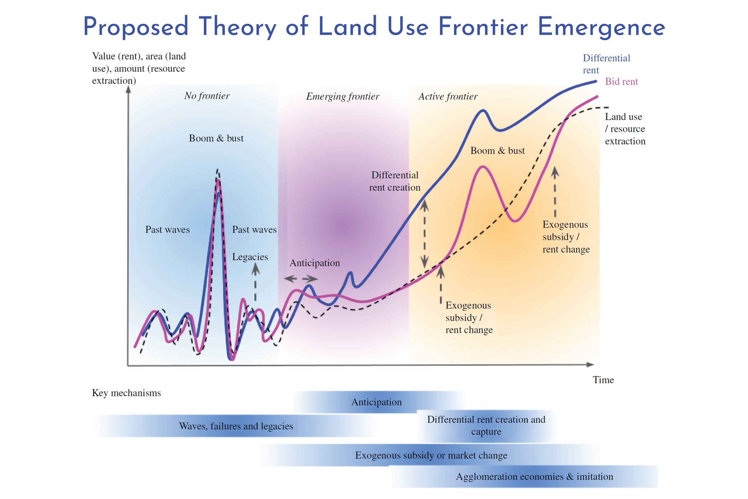
Explaining the Emergence of Land-Use Frontiers
Land-use expansion is linked to major sustainability concerns including climate change, food security and biodiversity loss. This expansion is largely concentrated in so-called ‘frontiers’.’ Understanding the mechanisms shaping these frontiers is crucial for sustainability.
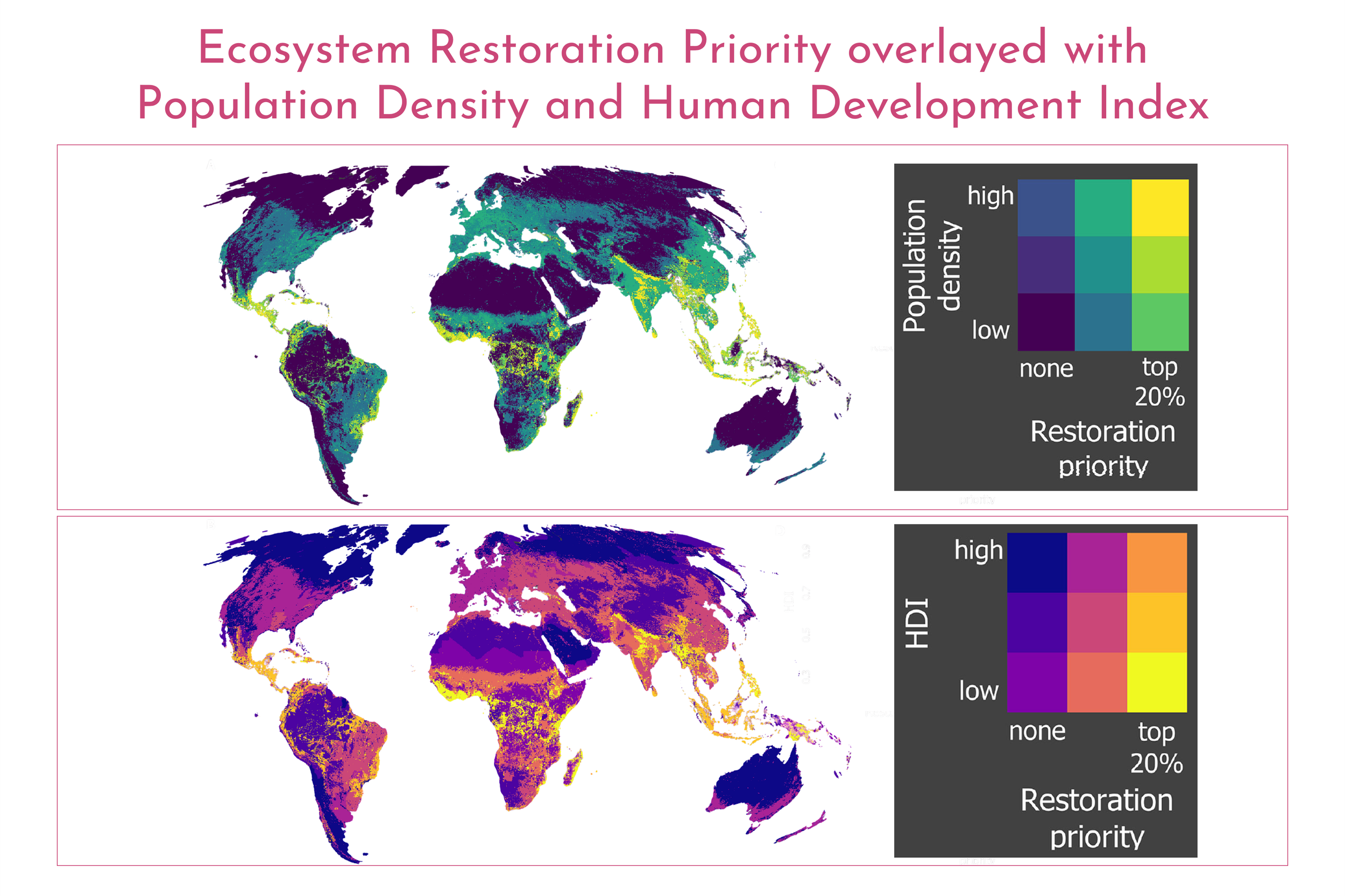
How Social Considerations Improve the Equity and Effectiveness of Ecosystem Restoration
Ecosystem restoration is an important means to address global sustainability challenges. However, scientific and policy discourse often overlooks the social processes that influence the equity and effectiveness of restoration interventions. In the present article, we outline how social processes that are critical to restoration equity and effectiveness can be better incorporated in restoration science and policy.
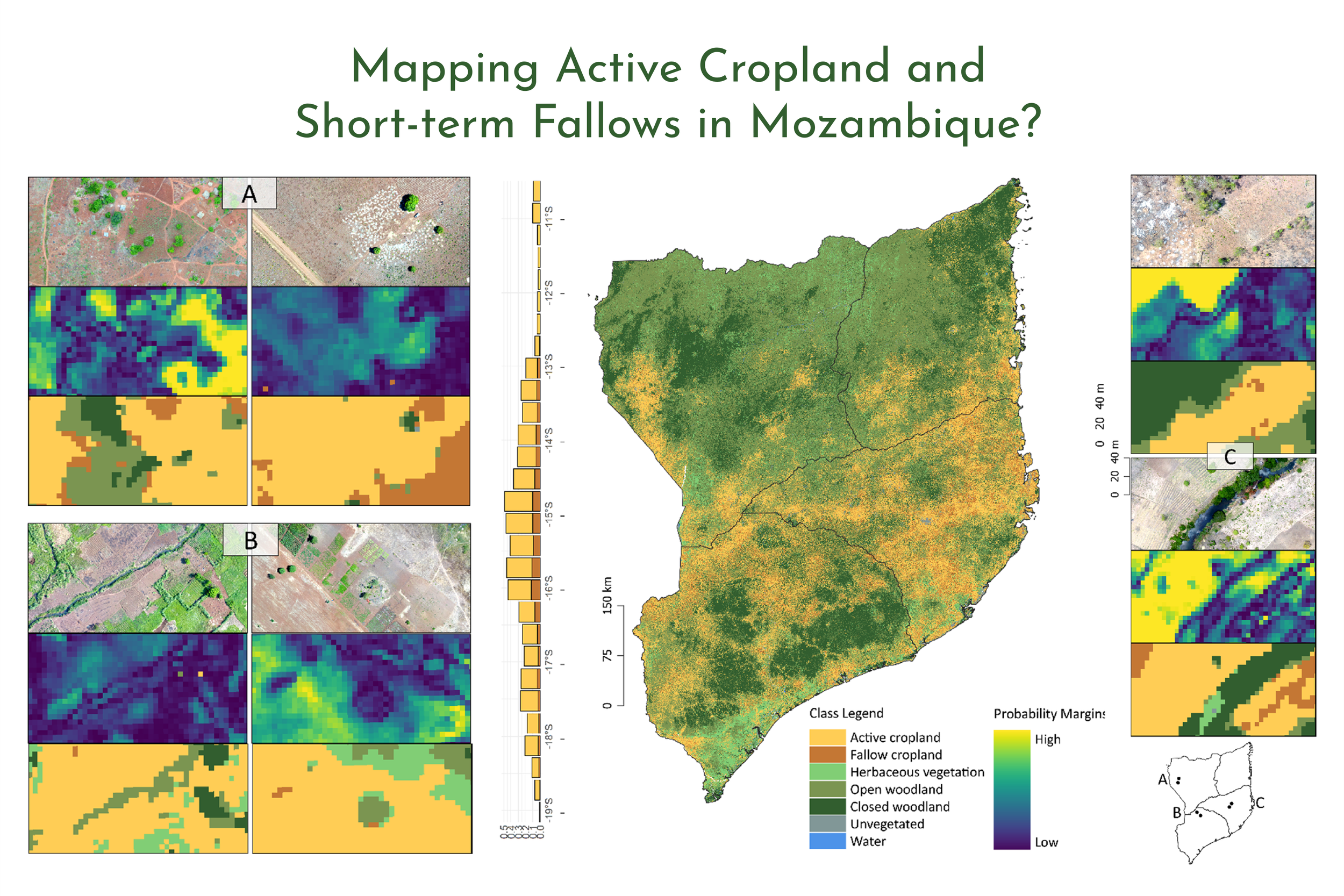
Large-Area Mapping of Active Cropland and Short-Term Fallows in Smallholder Landscapes Using PlanetScope Data
We present a large-area mapping framework to identify active cropland and short-term fallows in smallholder landscapes for the 2020/2021 growing season at 4.77 m spatial resolution.
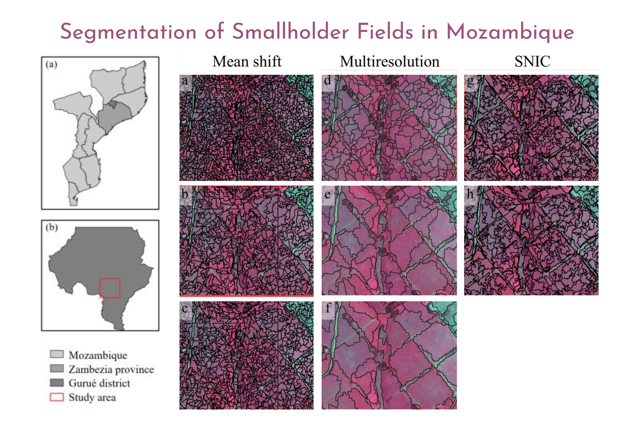
Unsupervised Segmentation Of Smallholder Fields In Mozambique Using PlanetScope Imagery
This study compared three unsupervised segmentation approaches that have not been widely explored for delineating smallholder fields: mean shift, multiresolution segmentation, and simple non-iterative clustering (SNIC), using PlanetScope imagery.
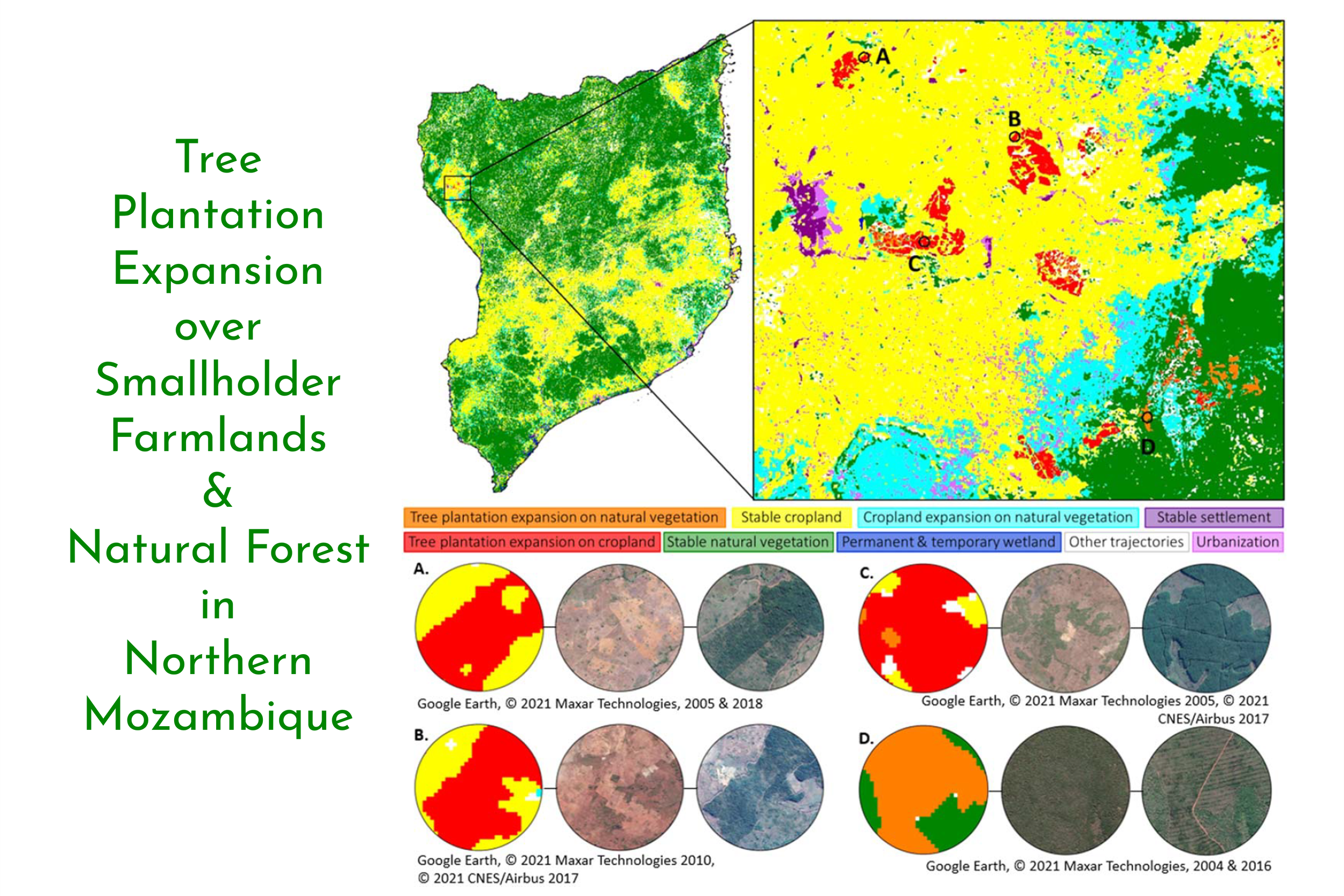
Improved Land Monitoring to Assess Large-scale Tree Plantation Expansion and Trajectories in Northern Mozambique
Tree planting has the potential to address a wide range of environmental and economic challenges. However, planting initiatives can also do more harm than good. Characteristics such as land tenure and land use before conversion to tree plantation are key to assessing the potential risks and benefits of tree planting initiatives. Here, we present a new remote sensing technique to distinguish tree plantations from natural forests, measure plantation expansion, and specify pre-conversion land use.
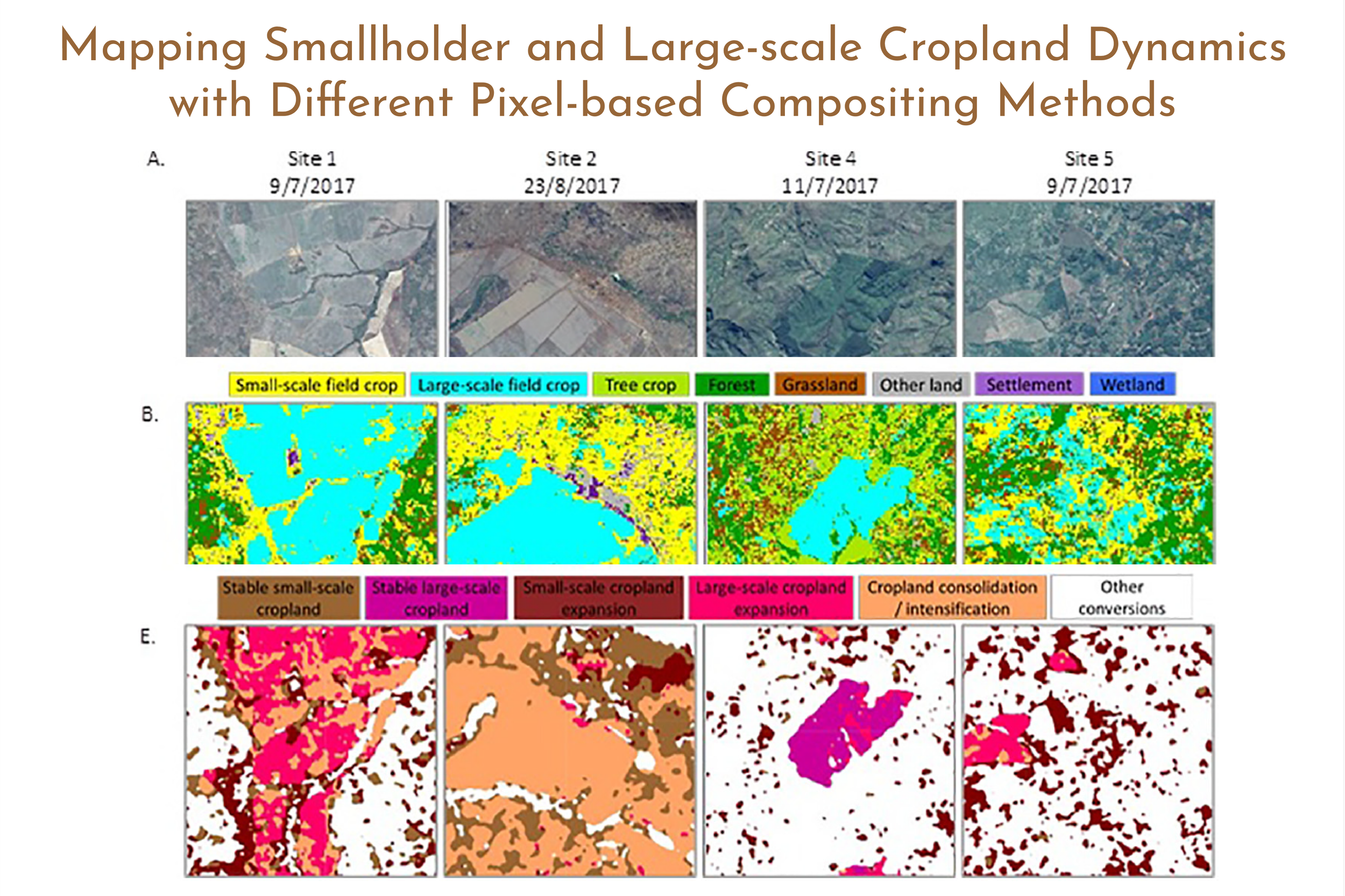
Mapping Smallholder and Large-scale Cropland Dynamics with a Flexible Classification System and Pixel-based Composites in an Emerging Frontier of Mozambique
(1) Pixel-based compositing impacts classification results. (2) Median compositing performed best for disaggregating cropland by field size. (3) Textural features facilitate the separation of small- and large-scale cropland. (4) Mapping cropland scale dynamics can improve understanding of land and food systems.

The Extent of Forest in Dryland Biomes
Dryland biomes cover two-fifths of Earth’s land surface, but their forest area is poorly known. Here, we report an estimate of global forest extent in dryland biomes, based on analyzing more than 210,000 0.5-hectare sample plots through a photo-interpretation approach using large databases of satellite imagery at (i) very high spatial resolution and (ii) very high temporal resolution, using Collect Earth software.
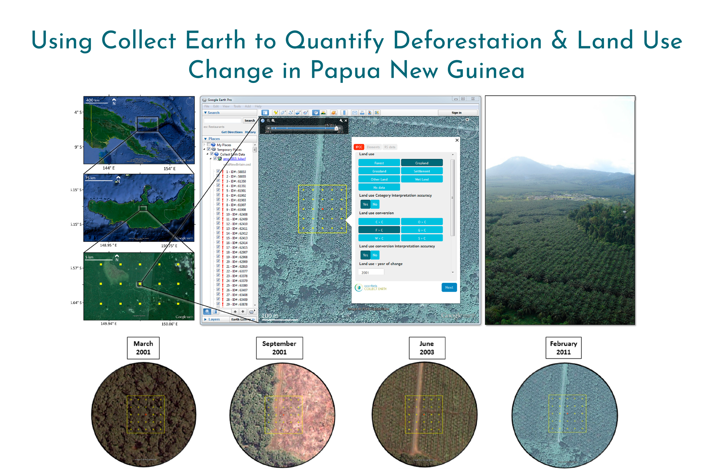
Collect Earth: Land Use and Land Cover Assessment through Augmented Visual Interpretation
Collect Earth is a free and open source software for land monitoring developed by the Food and Agriculture Organization of the United Nations (FAO). In this study, we provide a full overview of Collect Earth’s structure and functionality, and we present the methodology used to undertake land monitoring through augmented visual interpretation using Papua New Guinea as a case study.

Ecological Variability and Carbon Stock Estimates of Mangrove Ecosystems in Northwestern Madagascar
Here, we focus on Ambaro and Ambanja bays, presenting dynamics calculated using United States Geological Survey (USGS) national-level mangrove maps and the first localized satellite imagery derived map of dominant land-cover types. The analysis of USGS data indicated a loss of 7659 ha (23.7%) and a gain of 995 ha (3.1%) from 1990–2010. Contemporary mapping results were 93.4% accurate overall (Kappa 0.9), with producer’s and user’s accuracies ≥85%. Classification results allowed partitioning mangroves in to ecologically meaningful, spectrally distinct strata, wherein field measurements facilitated estimating the first total carbon stocks for mangroves in Madagascar.